
My bus pulled into the shoebox sized bus station in Huaraz at about 10:15pm. I had reserved a bed at Andes Hostel in advance, and the hostel sent me an email with information about my booking. After getting my backpack from luggage, I pulled up the email from the hostel. I scanned it and found it didn’t actually have an address (wtf). It simply had the phrase, “We are located near the Plaza de Armas. Facing Iglesia San Francisco turn right and head up the hill.” With no data on my phone, I couldn’t search the address. I asked a local at the bus station, and he told me the Plaza de Armas was close: two blocks over, then two blocks up.
Exiting the bus station, I was swarmed by taxi drivers trying to earn a fare. But after being told the Plaza was right around the corner, I decided to just hoof it. Another part of the reason I decided to walk is because the cabbies outside bus stations try to gouge gringos. One guy, offered a ride for S./5, about $1.50, which I laughed at. It’s funny, after becoming accustomed to prices in Peru, and having previously gotten a 10 minute cab for S./2, I scoffed at the thought of paying 5 Soles for a ride of only a few blocks. “This place was right around the corner, who does he think I am?” I thought.
Huaraz is a busy little city positioned at the foot of the Andes Mountains. There’s one main street, Avenida Mariscal Toribio Luzuriaga, where the majority of commercial enterprises are situated and modern buildings can be found. The further from the Avenida, the more of a relic the city becomes, with cobblestone streets lined by adobe houses built into the foothills of the mountains. Near the Avenida, it feels like the city’s entire population of 100,000 is out at once with busy street traffic, endless street vendors, and swarming foot traffic all creating commotion at once, but three blocks away the pace slows as the architecture matures.
I made it to the Plaza de Armas, stood in front of the church, turned right and headed down the street. But there was no hill, it was flat, downhill if anything. I went anyway. I headed three blocks down, nothing. I headed back. “Maybe they meant ‘turn left’ when facing the Iglesia, sometimes they mess up their English translations,” I thought. I headed left, but still no hill. A slight incline, but no ‘hill’. Then I figured, they said it was close to the Plaza, let me just scour the surrounding two blocks. Nothing.
At one point, I was walking down a street and heard bottles clanking and saw a few hombres on a stoop with a makeshift barbecue flaming on the sidewalk in front of them. I knew they were drinking, and here I am, a gringo with two backpacks, clearly lost. My mind told me to take a detour, but I was on a street heading up a hill. I wanted to continue on the street, thinking my hostel might be up ahead. I went for it and walked by them on the far side of the street. At first they just looked at me, then I nodded at them and smiled, and they all had a ‘get a load of this gringo’ laugh.
It was now well past 11. I started asking locals if they knew the hostel. Nothing. Then I realized the church on the Plaza de Armas is usually La Catedral, not Iglesia San Francisco. I asked a local to confirm, “Noooo, es La Cateedralll. Iglesia Sanfranceeessco es ayeeee,” gesturing a ways yonder, confirming my mix-up. No, this is the Cathedral. Church San Francisco is over there. I tried to clarify exactly where it was, but he wasn’t sure. About three blocks over and two up, he guessed. I humped it over there, with my two backpacks and tote bag, fatigued and feeling their weight. Nothing. I kept walking around, looking for a church and found one. “Yes!” Nope, this one was a small church of a name I can’t remember. “Fuck!”
The streets were empty now. No people, no cabs. I eventually ran into a teenage girl and asked her for Iglesia San Francisco. She said it’s nearby, but she can’t remember exactly where it is. I keep looking. My chest and back are soaked through with sweat where my backpacks rest. I’m getting exasperated. Finally, a cab rolls by and I flag him down. I tell him my hostel, he knows it, and tells me it’ll be S./3. I agree, exhausted. He takes a left at the first intersection and heads three blocks up. We pass a big church on the left, and I sigh. He heads another block down, then about 150 meters up on a street at about a 40 degree angle, stopping in front of a dimly lit sign for the Andes Hostel just past midnight. It was a 4.5 block away from where he picked me up, for S./3 or about $1, almost two hours after I arrived and scoffed at a $1.50 cab ride. Quite the slap upside my noggin, after my head had gotten big and I thought I had this travel shit all figured out.
I checked in and was shown my bed, a top bunk of a fully booked 6 bed dorm. Everyone else in my room was already in bed, which I thought a bit odd (usually at least one or two people are still up at this hour). I quietly tried to get situated and ready for bed, tired from the road and humping it with two packs all over the city.
I was awakened at an ungodly hour to several people in the room moving about, going through their bags, and packing up. “Who the fuck, checks out at 4:30am” I thought. Turns out they were leaving for a trek.
Huaraz is one of the most popular destinations in South America for hiking, trekking, and mountaineering. Not having done proper research, I had come to Huaraz mainly because it was one of the larger cities between Lima and Trujillo. It was a stop to save me from the drudgery of a 12 hour bus ride straight to Trujillo. I knew it was a mountain city and had naively planned to do some hiking, but I was quite unaware it is a world renowned mountaineering destination. This dawned on me the next day when a group of Europeans, showed up at the hostel with a full assortment of mountain climbing gear, including helmets, ropes, harnesses, ice axes, and mountaineering boots complete with crampons for ice climbing. ‘Hiking’ is small potatoes here.
After coffee the next morning, I headed to the office of the hostel where there is a guy who arranges treks for guests. He explained to me the various routes and treks, some of which seemed insane to me. A 12-day trek at 5000m+ above sea level…are you fucking kidding me? Oh, but they can provide all the gear I need, at a great price! Yeah, right. However, one popular multiday trek, the Santa Cruz, seemed within the realm of possibility. It is a 4-day trek, with Sherpa-like guides to navigate and fix meals, and mules to carry the big packs and equipment. Before committing to anything that intense, I decided to try a couple of day hikes the following two days. First, Laguna 69 (aka Lago 69, Lake 69), and then the Pastoruri Glacier the day after.
I spent the rest of the day scouting out the city and gathering food and supplies for my hikes. Laguna 69 is an 8 hour hike, with 1.5 hour van ride just to get there, leaving at 5am. So, I was going to need to pack at least breakfast, lunch, and water, probably some snacks as well. I wound up buying eggs (which I soft boiled), avocados and limes, sardines, trail mix, chocolate, and fruit. A Hodge-podge of mostly high fat and protein food for long-burning energy, but also some sugar in the chocolate and fruit for fast-burning energy. In hindsight, I should have got some coca leaves too, which I later learned the guides are constantly noshing on during treks for both energy and because it somehow helps with the altitude.
I had dinner that night at Don Vito’s Polleria. Pollo a la Brasa (roasted chicken) is a big thing in Peru. I had somehow not had it yet, and decided to remedy that at Don Vito’s. Holy fuck! It was amazing. They slow roast chickens in a brick oven for like 6 hours, pulling them out at regular intervals to brush with herb and spice laden basting liquid. The restaurant is only open for dinner, and only has something like 40 chickens available per day. I didn’t know any of this, just saw a decent looking Pollo a la Brasa place, and was like ‘Oh, I need to try this while I’m in Peru’ and wandered in. It happened to be Tuesday, a slower day, so I was able to walk in and get seated, when usually you have to wait. On top of all this it was only S./15 (less than $5) for a quarter chicken, two anitcucho skewers, potatoes, and salad.
I returned to the hostel, did some reading, and then turned in really early at 9:30ish in preparation for my hike.
The next morning, I was the asshole moving about the dorm at 4:30am. I got dressed and packed my daypack with my meals, water, some extra layers, and sunscreen. I was in the lobby by 4:50 and headed to the kitchen to make some coffee, but the kitchen was locked. W.T.F. Some motherfuckers looking to die, coming between me and my coffee at 4 in the morning?! Turned out to actually be a good thing, so I could sleep on the van ride there. The van showed up at about 5:10am. Six others from my hostel and myself loaded into the van where five people from another hostel were waiting.
I slept for about an hour as the van cruised north on a highway through the mountainous Ancash region. When we reached Yungay, the van headed East into the mountains, where we were on rock and dirt roads too bumpy to stay asleep. The van ascended the cliff-side roads, barreling through switchback after switch back, my ears popping from the altitude along the way. We stopped at a roadside café along the way for bathroom break and snacks. I got the coffee I longed for. Eventually we reached the Cebolla Pampa campgrounds, at about 8:30am.
The guide explained the bus would leave at 4:30pm. He would be the last to ascend and descend, trying to make sure we were all accounted for. We signed a registrar to document we were doing the hike in case anything happened, and that was it. The guide pointed to the trail through the valley, and we were at our leisure to begin the hike.
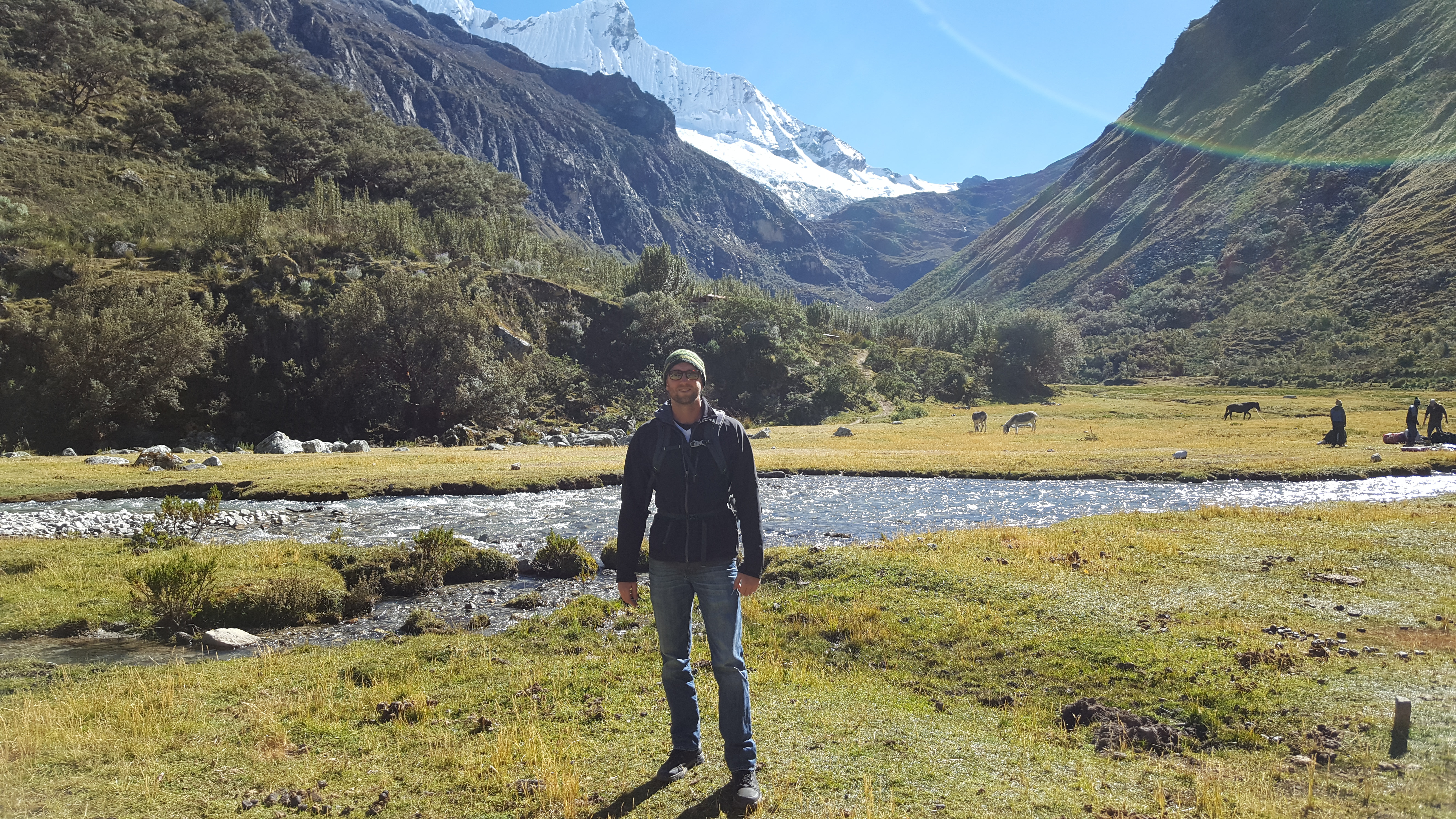
I began the hike by myself, traveling through a valley and into the first mountain. The hike basically progresses through a valley, up a mountain, down through a mountain pass, through another valley, and up another mountain until you reach the final destination, the glacier-fed Lake 69. It starts at about 3800m above sea level and ends at about 4800m. The trekking is difficult. The cliff-side trails are narrow, craggy, and rocky, going up the face of a mountain, switchback after switchback. Almost every step requires your attention as you must choose your footing carefully to maintain balance and avoid rockslides. The trails are steep generally at minimum of 35 degree angles, and in several places it is as thought going up a set of stairs where the steps are each two feet high and the staircase is positioned at a 70 degree angle. Moreover, the ‘steps’ are narrow and craggy, often requiring you to take 2 or 3 steps at once, as you need to use your momentum else you will not be able to maintain balance on some of the tiny, uneven footholds.
I was working my way up the first mountain, shirt wet with sweat, exhausted, heart pumping in, gasping for air. I figured I had been going for about an hour and 15 minutes, and should be about a third of the way there. I looked at my watch and stared in horror. It had only been 25 minutes. Doubt meandered through my mind. “Am I going to make it?” I wondered. I took a drink and pushed onward.
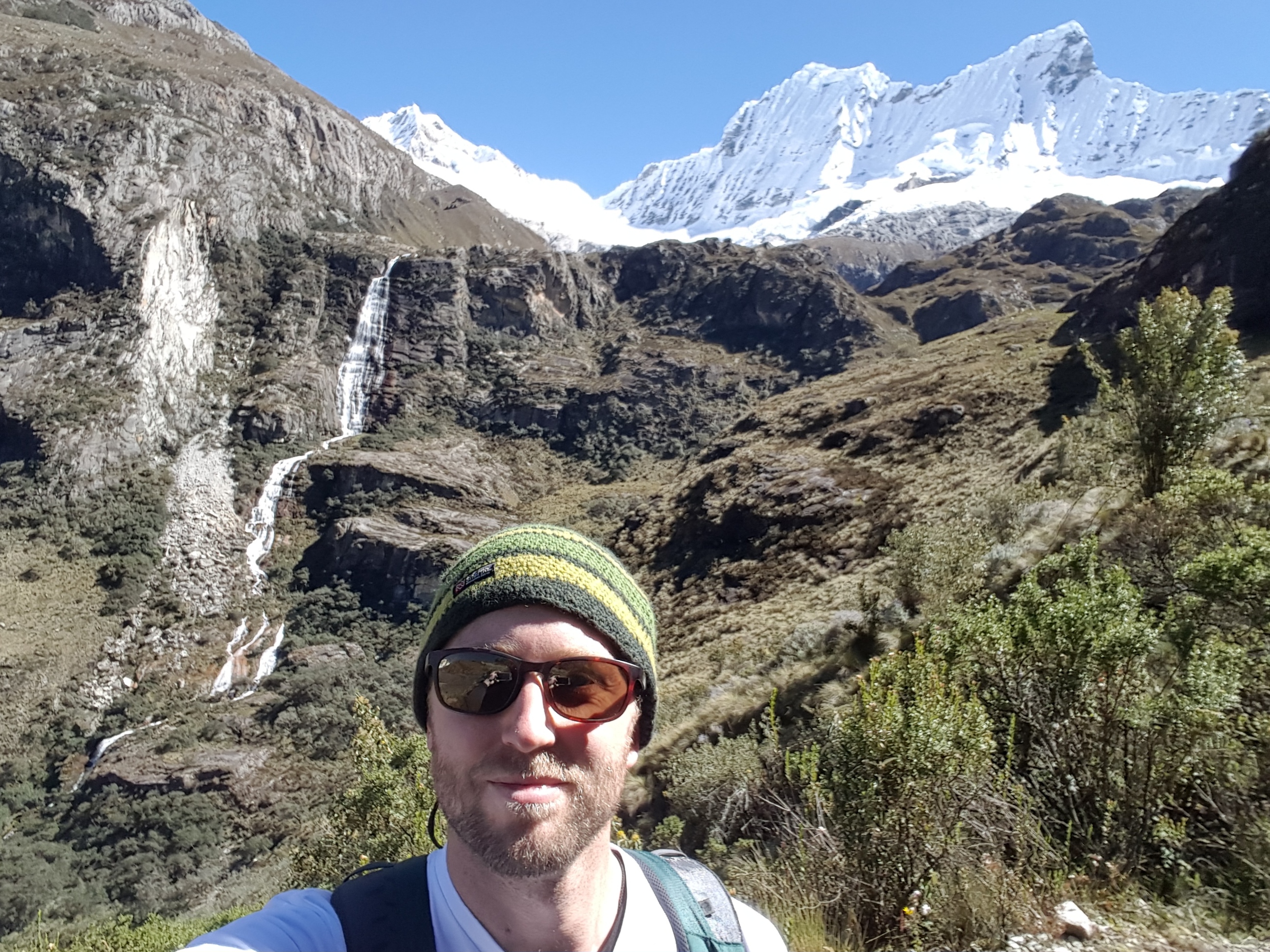
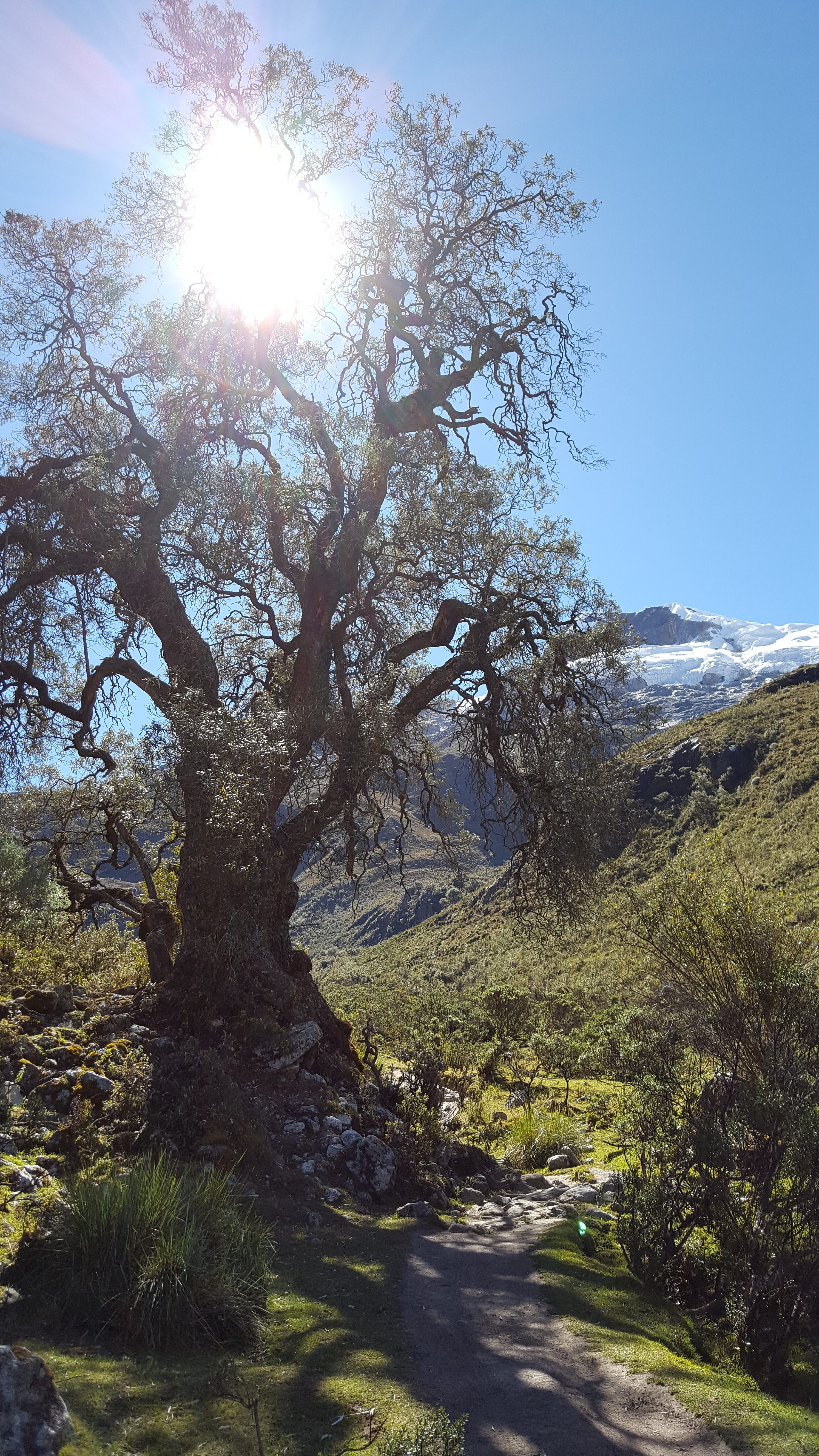
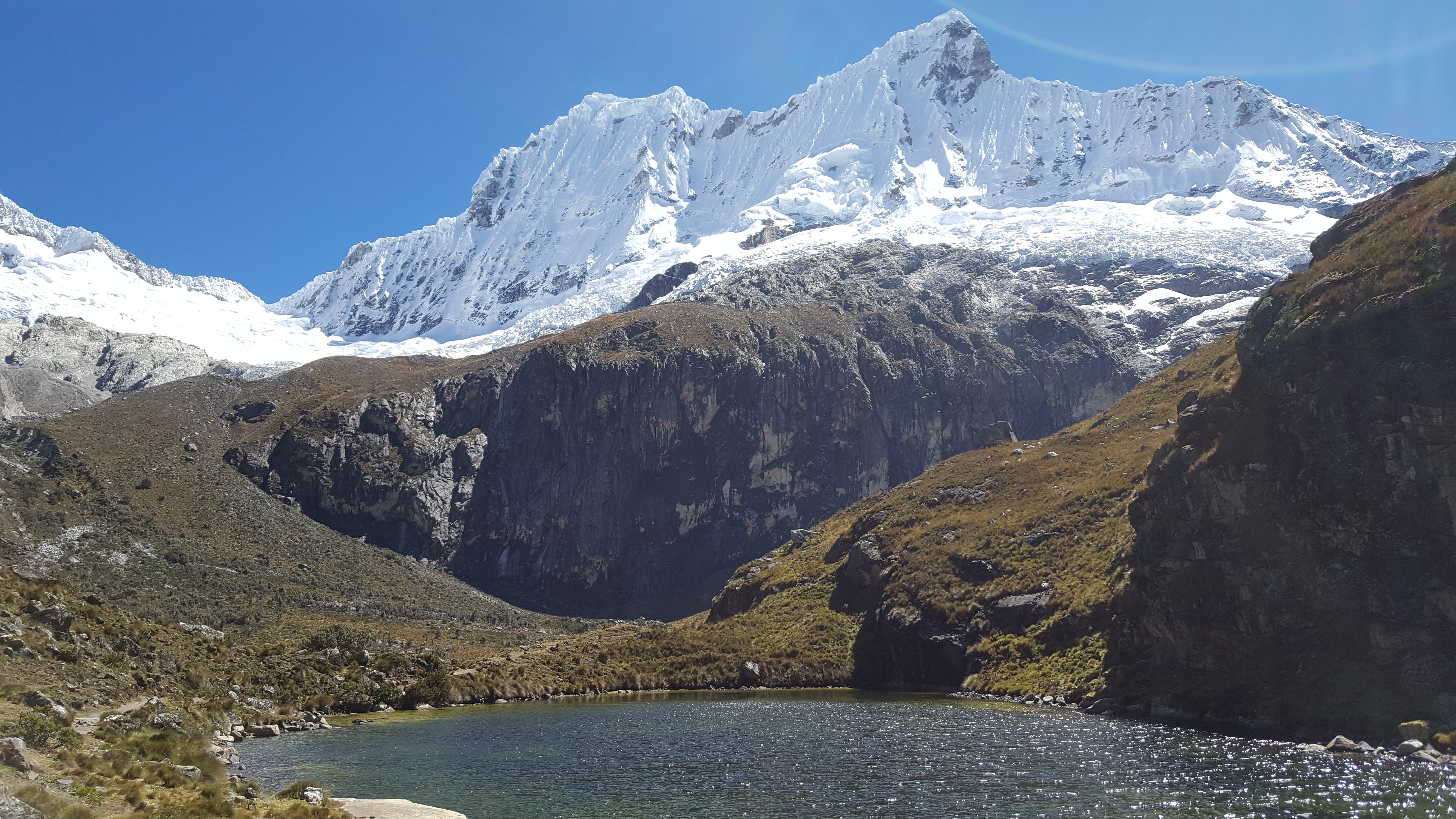
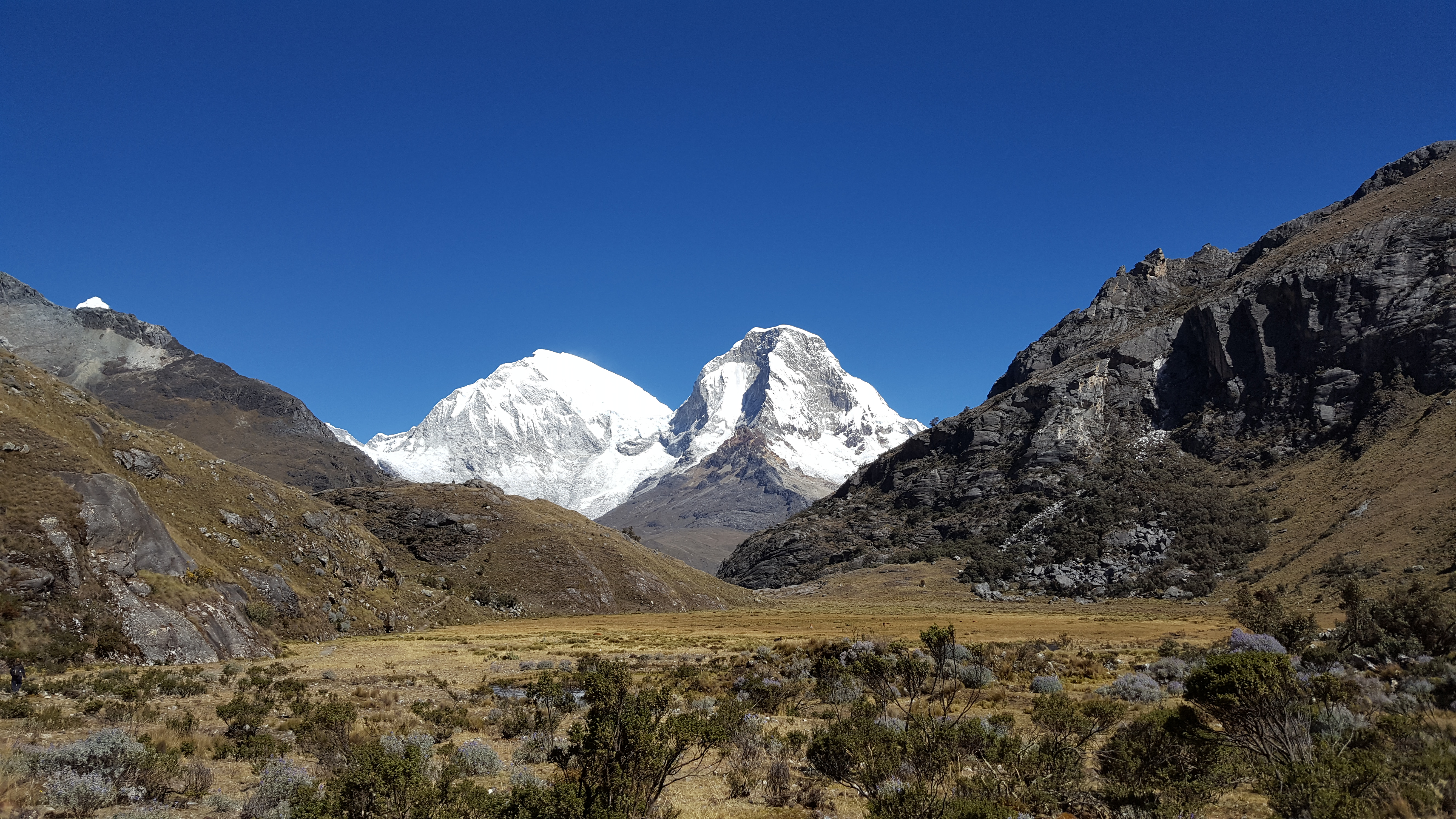
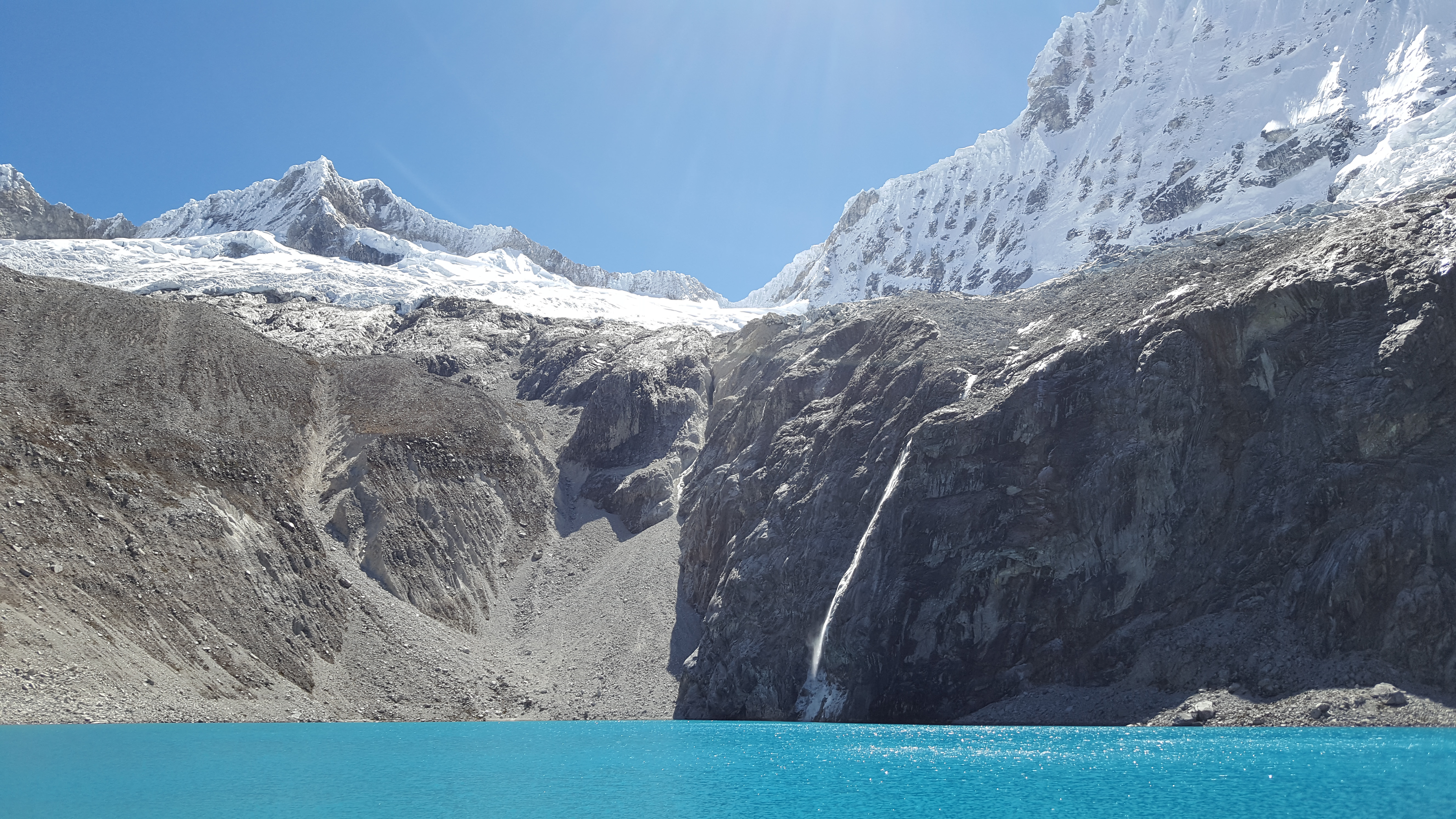
Even though I was struggling, I was enjoying myself. When I was hiking I was getting deeply into the physical aspect of it all, trying to keep even, steady breaths to correspond to even, steady strides. I was laboring, head down, breathing heavily with each step along the craggy paths. I had to stop every once in a while to pick my head up and take in the beauty I was immersed in. I was surrounded by the snowcapped Andes, waterfalls, crisp mountain air, wildlife, and a beautiful blue sky. It was one of the most magnificent views I’ve ever seen, and it was like this for the whole trek. I had to keep reminding myself to not concentrate on my labored hiking, but to focus on the beauty of nature surrounding me.
During the last ten minutes or so of the first mountain climb, I experienced my first symptoms of altitude sickness. The climb was difficult to this point and I was breathing heavily, but now I got a bout of dizziness. I was at a switchback and took a big, lunging step 2 or 3 feet upward and when I stood up fully became light headed and dizzy, and almost stumbled backward but not for grabbing a root jutting out of the wall of the mountain. If I had fallen off the edge of that switchback, it would’ve been a minimum of 60ft downward before my tumbling would come to rest. Whoa. Scary.
I took a seat to drink some water, and tried rapid, deep breathing, almost as though trying to make myself hyperventilate, to oxygenate my blood. Doubt was creeping in again. I wasn’t even halfway there yet. I ate some (Addison) trail mix, and concentrated on my breathing, yoga-style. In a few minutes I felt well enough to proceed.
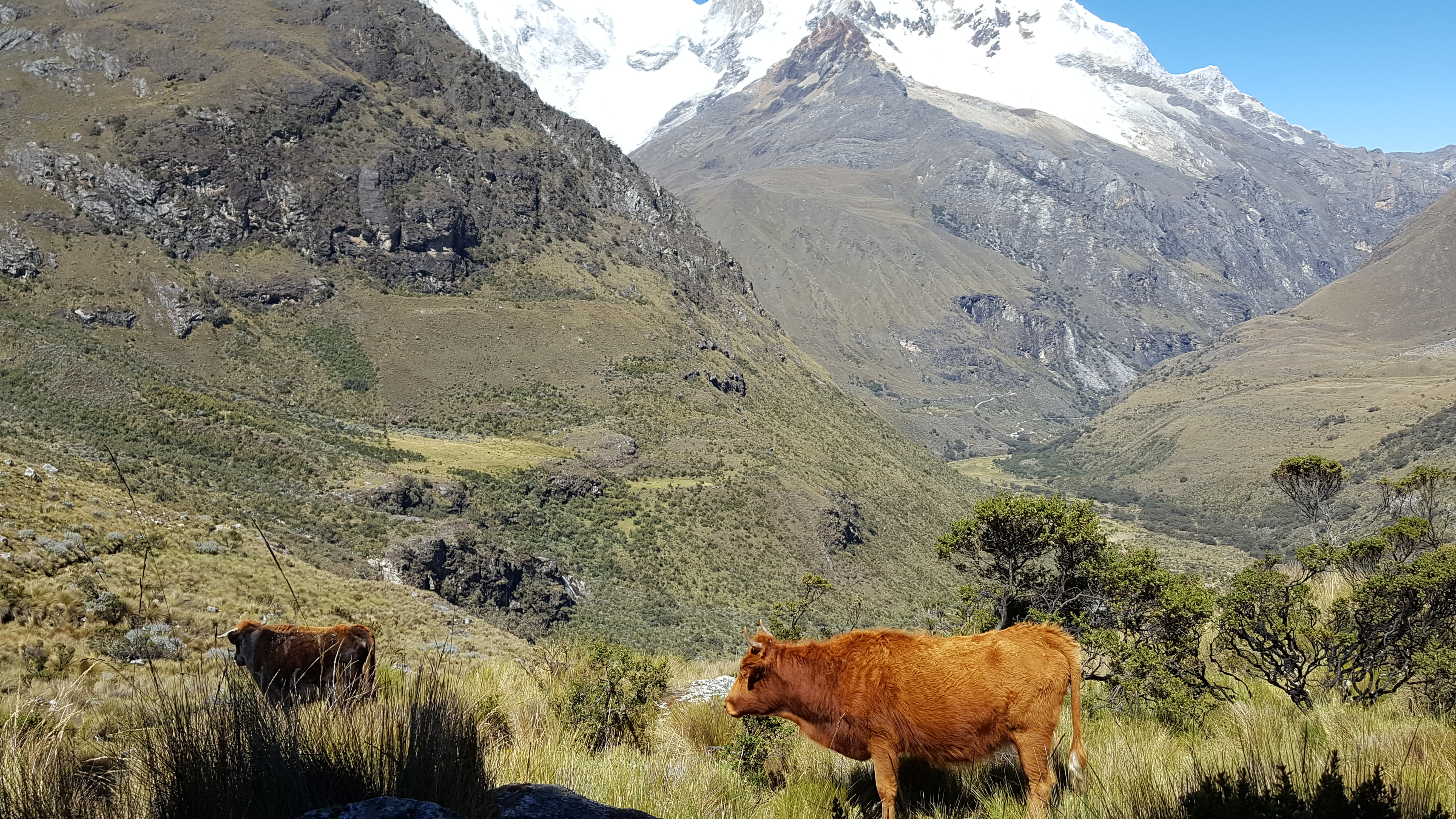
Through the mountain pass and down to through the valley, I felt somewhat better. It was still a labored walk through the beautiful grass covered valley. Though more of a walk now, it was still a steady 20 degree plus incline the whole way. The grass was short and soft, like on a golf course, punctuated by golden heather and streams. Cows and wild goats grazed, while chipmunks and guinea pigs darted around the valley. I had to cross a couple streams stepping on rocks, and at one point a rock shifted underfoot and I almost went in, but saved myself at the last second.
The second mountain was even more difficult than the first. The rocks on the paths were bigger, fewer good places to step, and more lunging steps upward. I took it slow, but about halfway up was really struggling. I had been in mountains before, but had never experienced altitude sickness like this before. My carotid artery bulged as it thumped like a bass drum for a heavy metal band. My lungs wheezed for air with every labored step. My head ached in uncommon places from the altitude. I cursed every extra ounce of weight that was in my pack and myself for having brought the deadweight. My phone charger? A deck of cards? “What the hell do you need that for on a mountain?!” I barked at myself. I regretted every cigarette and bong rip I had ever smoked, and pleaded with God if I could just make it through, I would reform my ways. I was resting every 5 or ten minutes or so, to catch my breath and try to oxygenate.
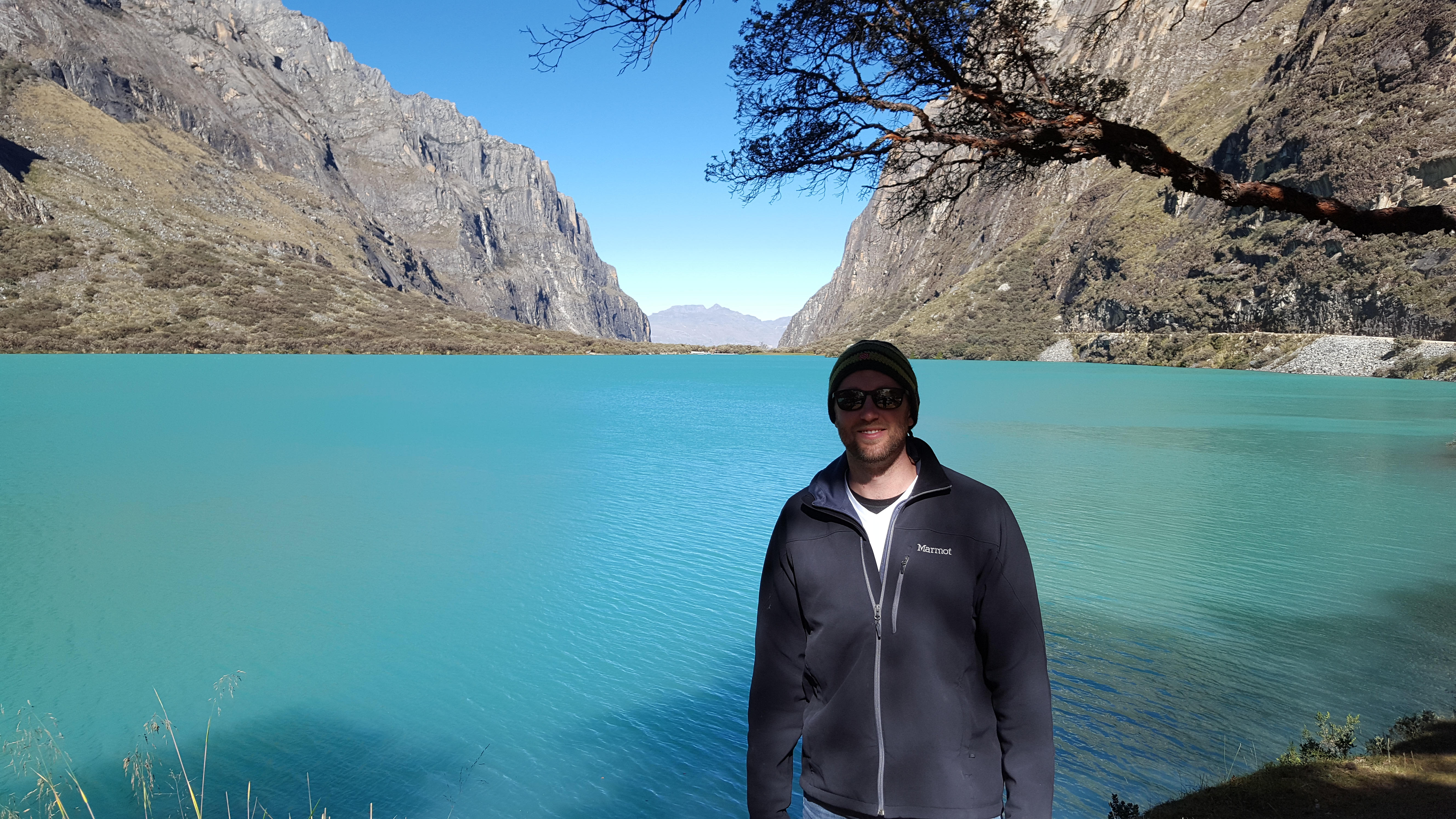
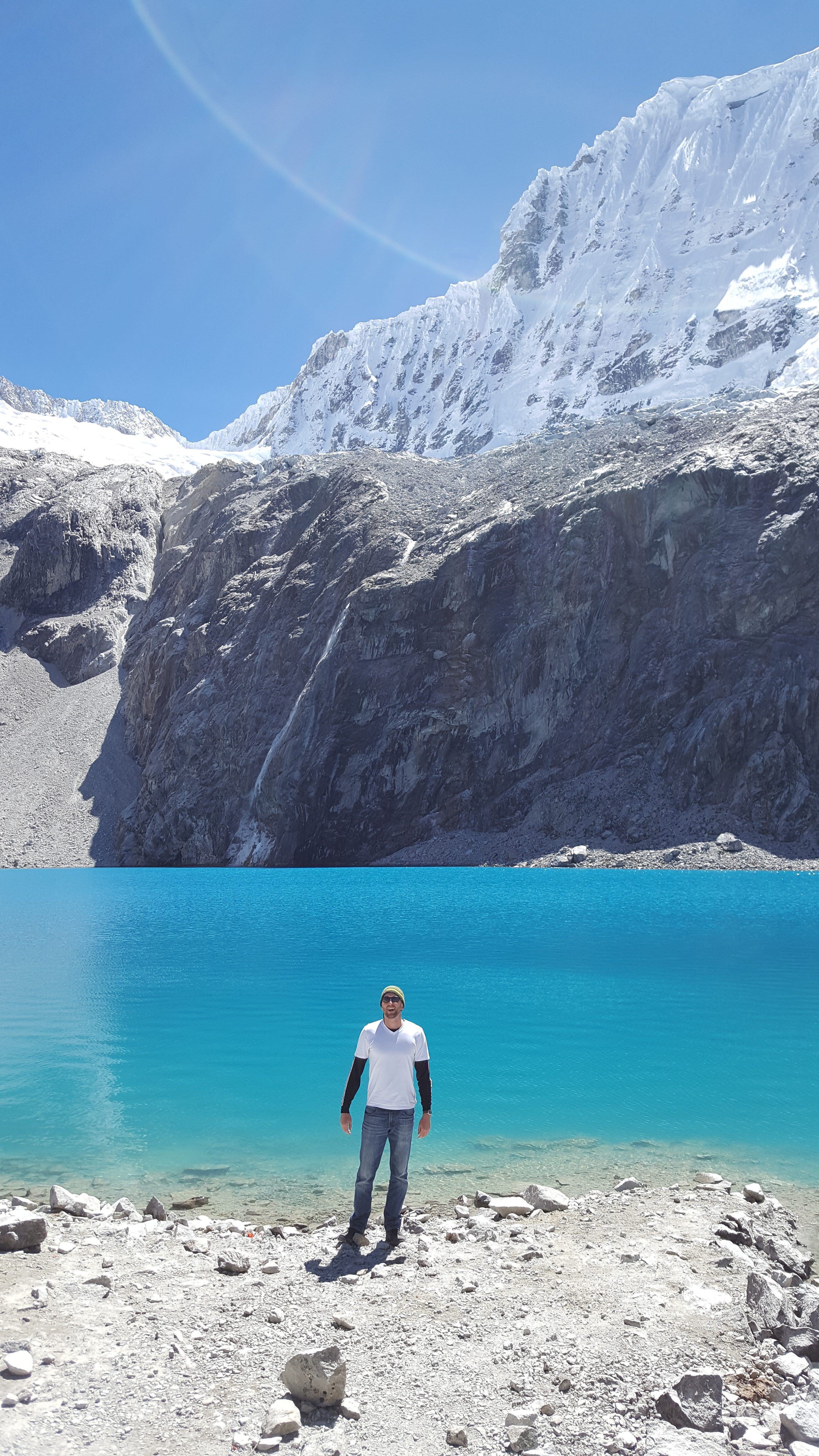
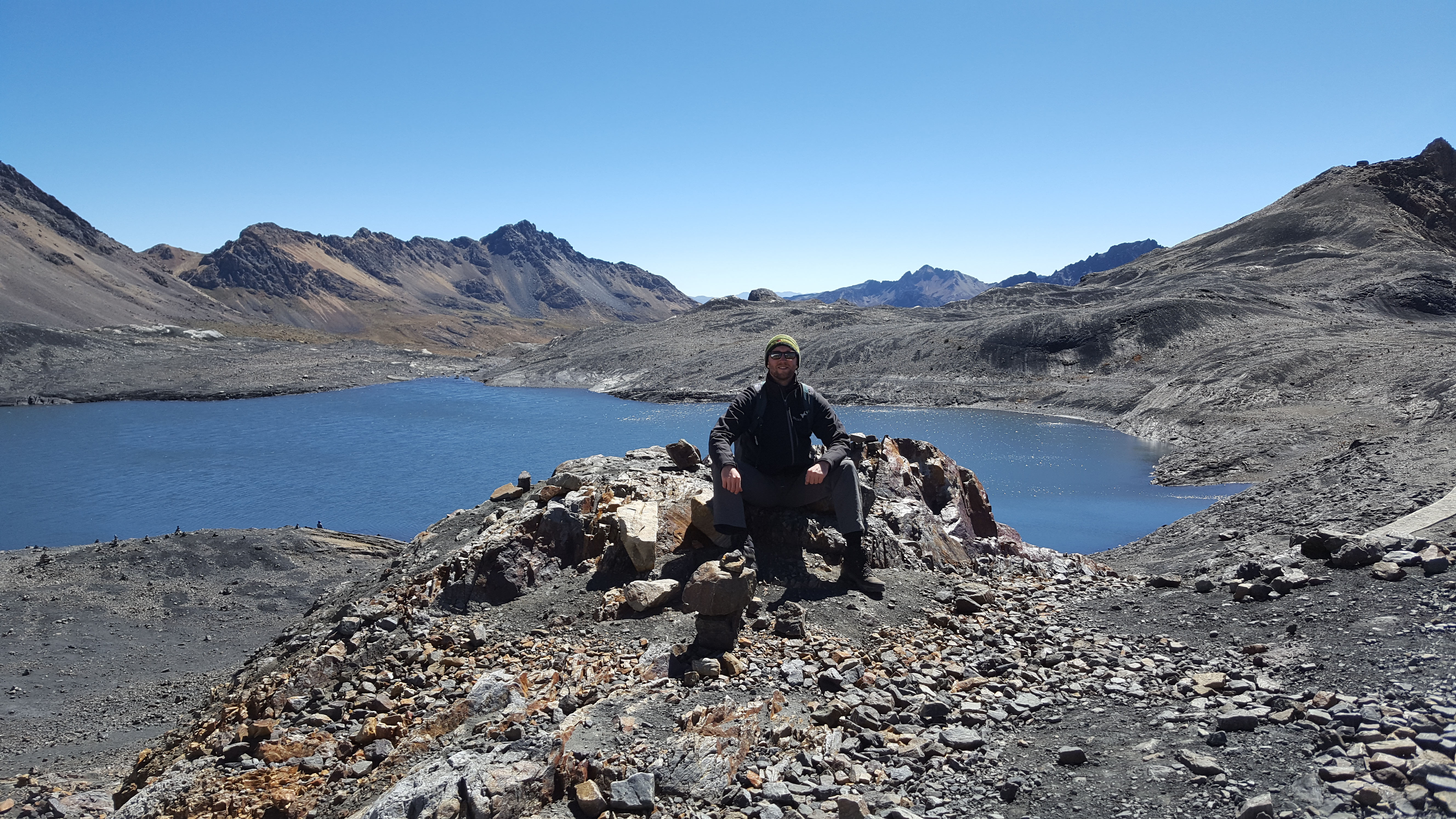
The last 20 minutes of the hike were horrible. It was the steepest part of the hike, at the highest altitude. I was literally having to rest every 10 to 20 steps. I knew I was almost there, but wasn’t sure if I was going to make it. I forged on, my head swimming. When I got towards the top, and saw the first glimpse of the turquoise blue water of Lake 69, I had a huge moment of relief. I was there, I didn’t collapse, and I didn’t wimp out and turn around at the last moment.

I heard some of the hardcore trekkers and climbers at my hostel talking about ‘earning the summit,’ and now I really knew what they meant. I was elated. It pretty much took everything I had to ‘summit.’ Despite all my struggles, I was surprised to see I was in the first dozen or so people to summit that day. I was the fifth of 12 in our group to make it, and a group of three girls had passed me in the final 20 minutes. I would have an hour to spend at the lake for lunch and viewing before beginning the descent.

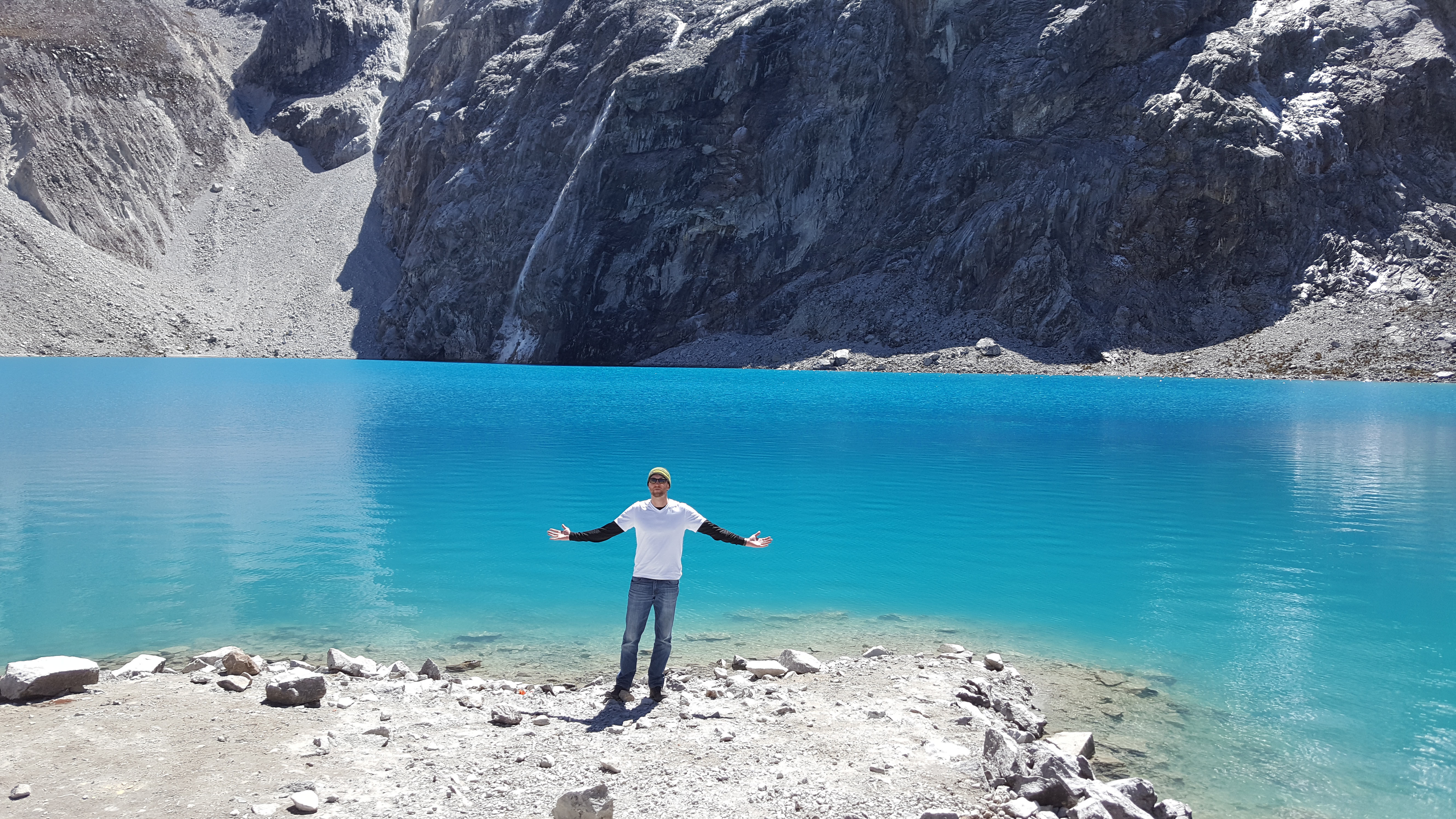

Some people jumped in the icy lake, which I was jealous of. I would have jumped in too for the cold thermogenesis effects if I had a bathing suit. As it was, I didn’t know you could go in the lake, so didn’t have a bathing suit, and didn’t want to hike down with a soggy bottom.
After wolfing down lunch, I tried to take a nap under a shrubby tree. I was interrupted by our guide saying everyone in our group had to begin the descent now. My back and legs had stiffened up considerably while resting. I was not looking forward to it.
During the first part heading downward, I came across many people heading upward who were struggling as bad as I was or worse. A group of people asked me how much farther, looking like they were at their wits end. “Fifteen more minutes. It’s a really shitty fifteen minutes, though,” I responded. Their faces winced.
I proceeded down the mountain slowly, my knees and back aching. I attempted to move slowly, so as to have sure footing and not take a tumble, but with downward momentum it was very difficult and at several points was moving at almost a jog. I had rocks slide underfoot many times, but caught myself every time, except once when I had a nasty slide on my already sore butt.
The descent seemed to take forever. My legs felt heavy, and my feet were sore and swollen. Despite all this, I was reminding myself of the incredible natural beauty around me, which seemed even more majestic with the slanting light of the afternoon sun poking through the clouds and mountains.
It was about 4:30 by time I made it to the van. I was the last person to make it to the van in our group. The camping area and valley were already dark as the mountains blocked out the sun. When I finally, piled myself into the van, I was extremely relieved. My head pounded with a headache, particularly in the back of my head. My body was sore, tired, and achy all over. I generally felt unwell. That was more challenging than I ever imagined at the outset. Oh beautiful naivety. If I had known how horribly difficult it was going to be, I may not have even went in the first place.
I dozed most of the ride back. When we got to the hostel, I was still feeling unwell. I immediately asked for a private room, to ensure I got a proper nights’ rest. Luckily, they had an empty privado, and I moved my stuff from the dorm. I read up on altitude sickness on the internet, and concluded I did not have a life threatening instance of it, despite the fact my head hurt badly, I felt frail and weak, and I had this weird, unsettling ringing in my ears.
I took off my sock, and my pinky toe, injured a few days prior while surfing, looked like a cherry. It didn’t even resemble a toe. It was spherical, and bright red with a hint of purple. It was like there was a clown nose covering my pinky toe. It had hurt for the first hour or so of the hike, but after that I had forgotten about it. Now I was looking at it, hoping it wouldn’t be permanently deformed (Cunningham-style).
I had an amazing hot shower, and then scrounged together a simple dinner from food I had on hand: rice, tuna, chocolate, fruit, and cacao tea. Bon provecho! I quickly went to bed after dinner at about 9:30pm. I had another hike the next day, after all. I was unsure if I would be able to go, and decided to evaluate my condition in the morning.
I awakened after a nice, long sleep at 7am. The hike was to begin at 9. I felt much better, but still had a slight headache in the back of my head. My body was a bit achy and stiff, so I did some down dogs and such which helped. I had spoken to a few others at my hostel who said today’s hike to the glacier was easier than Laguna 69, and I was feeling better, so I decided to do it.
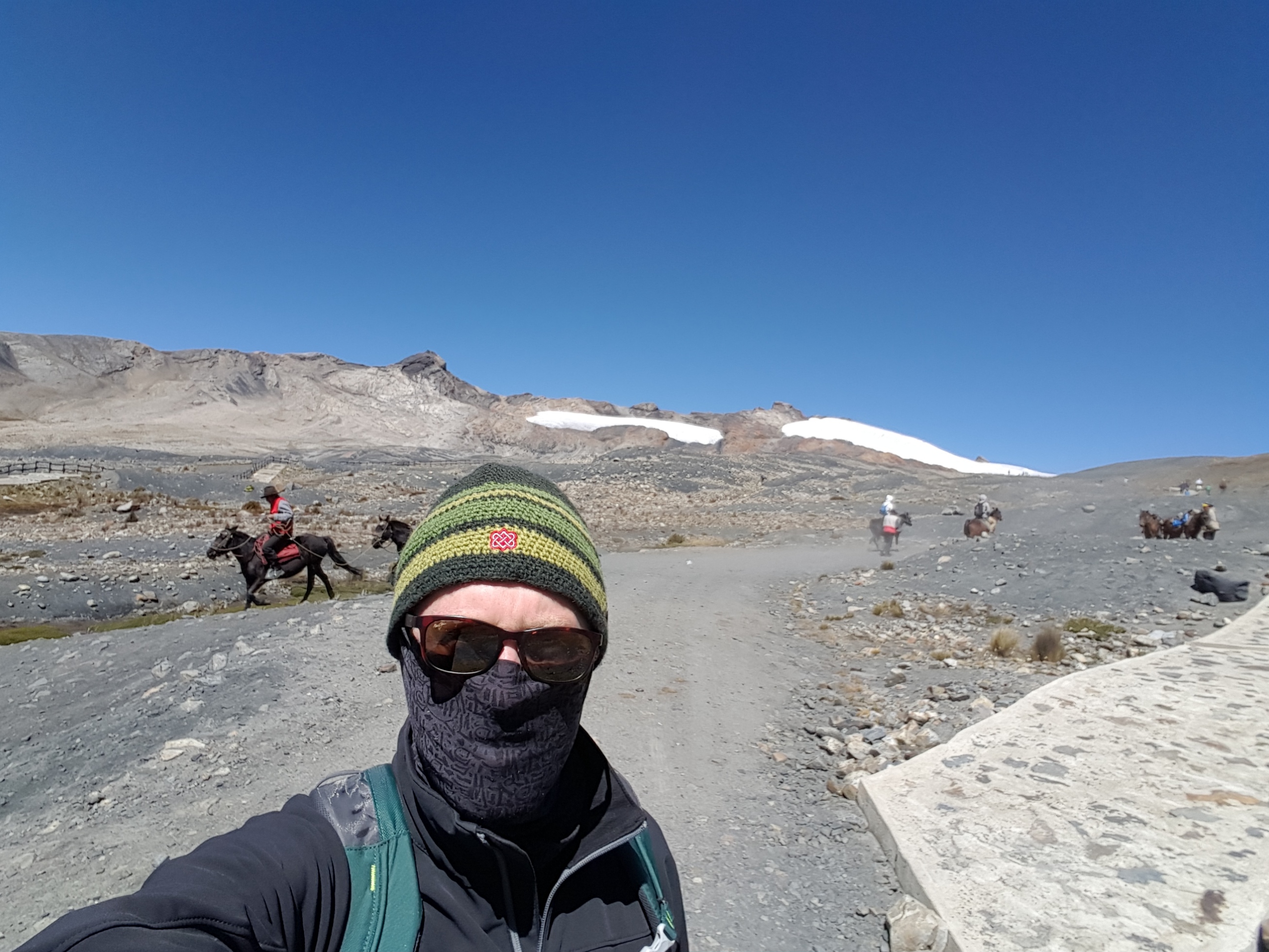
I had breakfast, with my coffee today, threw lunch in a bag and was in front of the hostel at 9 waiting for the van. This time I was picked up in a bus that would end up having about 20 people on it. We drove south 1.5 hours to the glacier. A good portion of that time, our guide was speaking into a microphone in Spanish, explaining the history and cultural significance of the site. I tried to tune in, but couldn’t keep up with the Spanish.
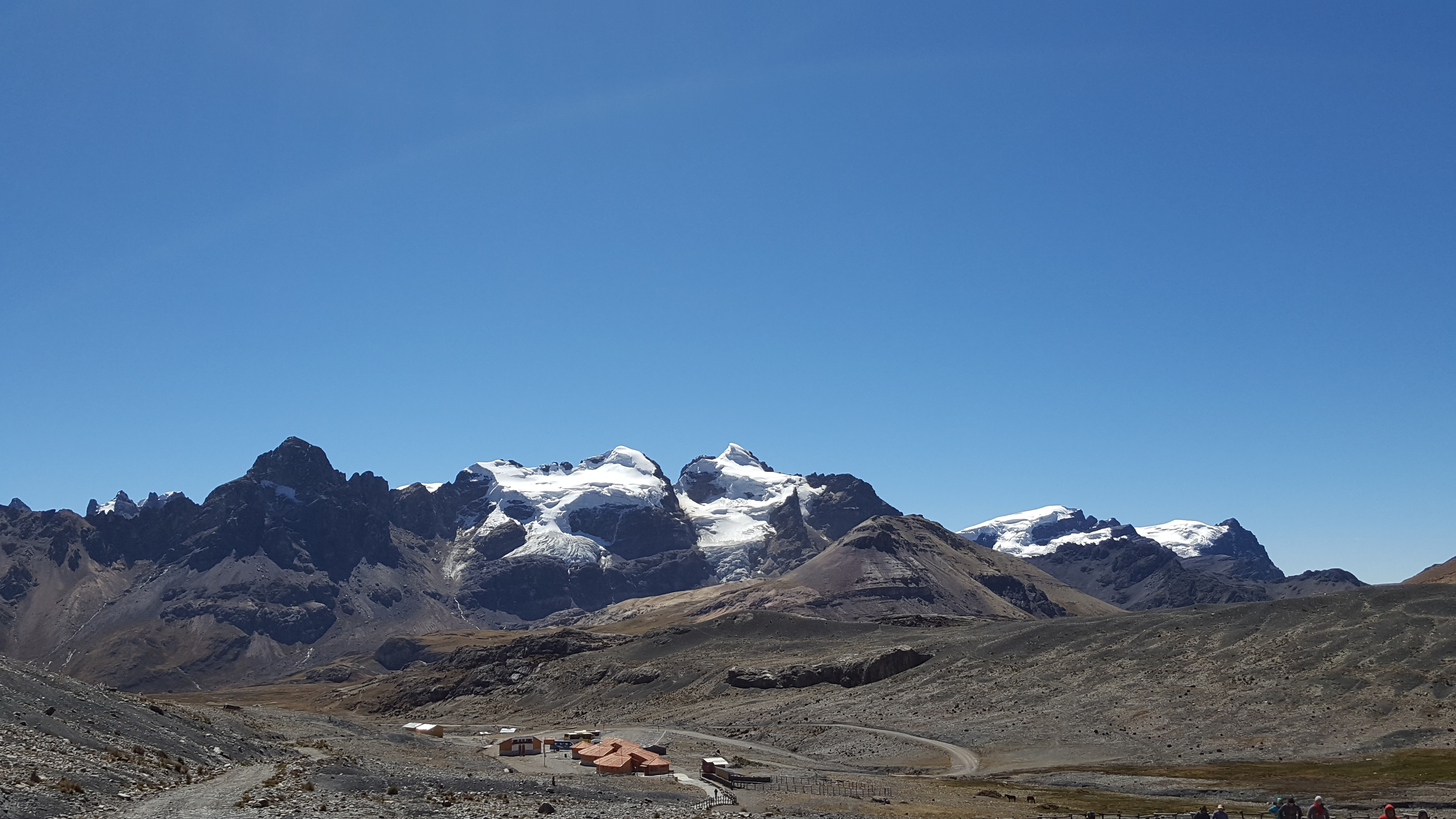
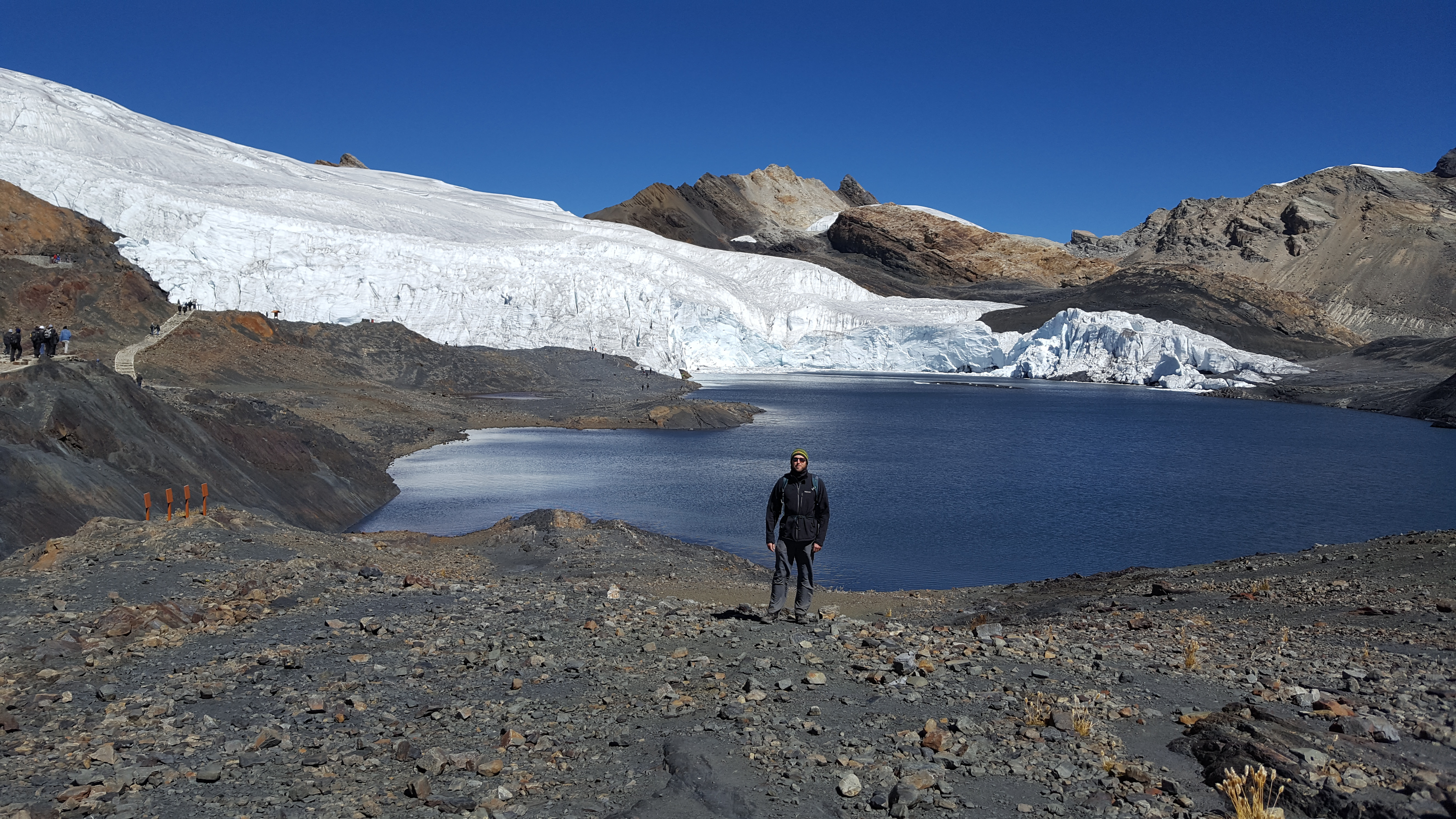
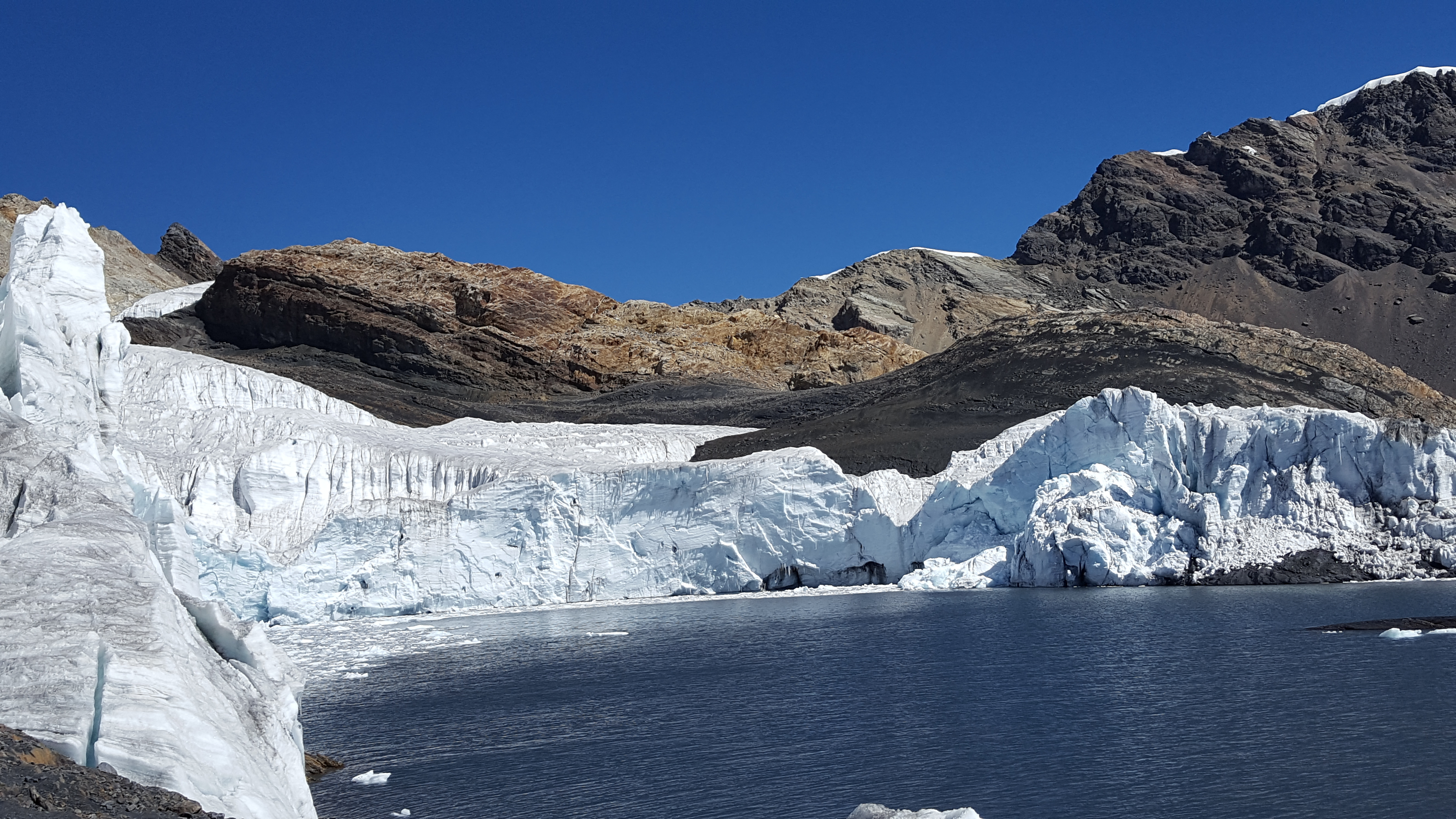
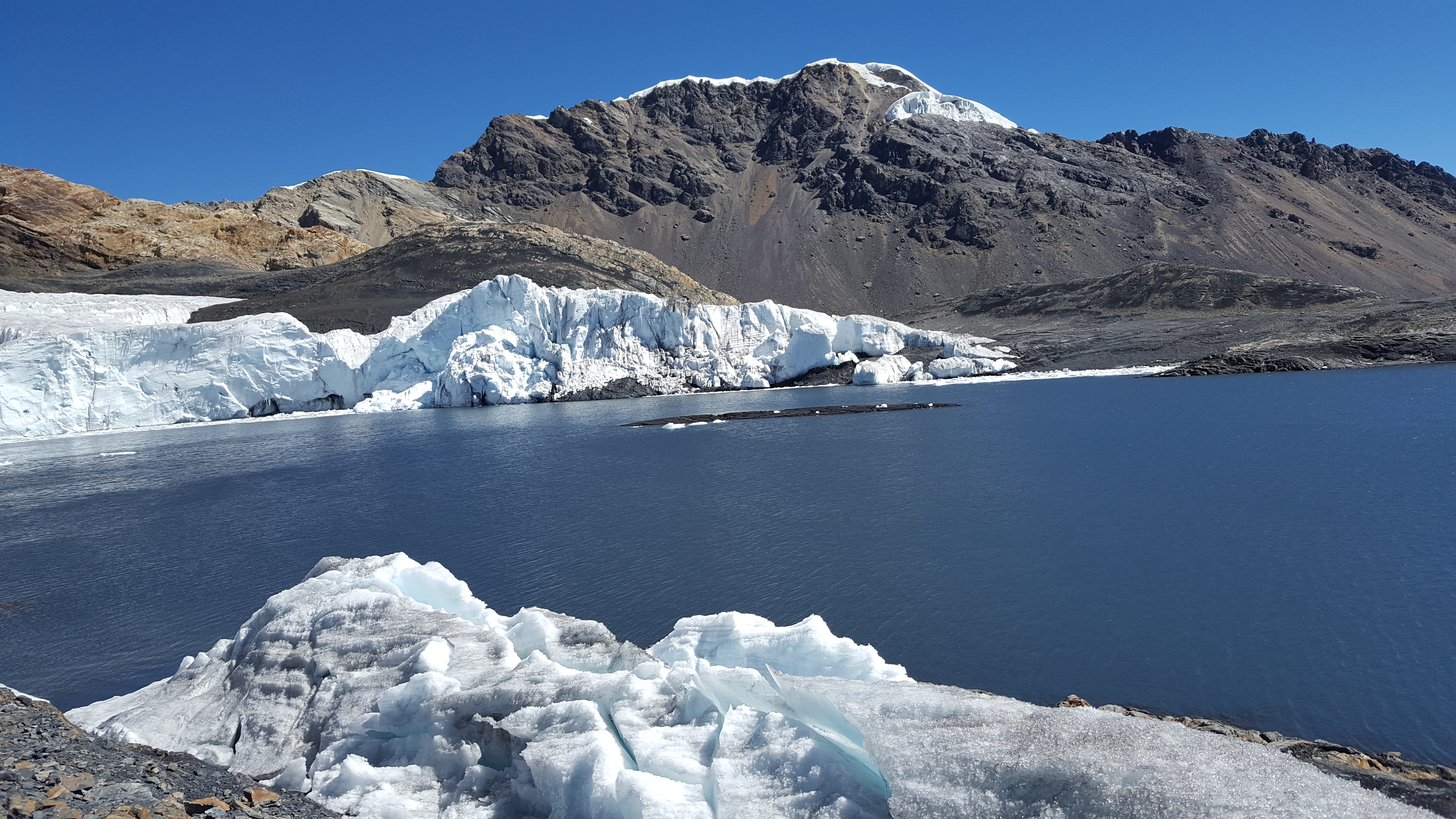
We arrived at the base of the hike. This hike only takes about 1.5 hours each way with an hour to spend at the glacier. This was a much needed reduction in the physical demands of the excursion. However, this one starts at about 4600m and ends at 5000m, higher altitude than yesterday’s trek.
The guide pointed us in the right direction and off we went. I started down a stone path and thought to myself, “Wow, this is nice. I wonder how long this path lasts before we get to the craggy trails on the side of a mountain.” As it turns out, the entire hike to the Pastoruri glacier is on the stone path. Although the altitude and incline were at times was difficult, this hike was like a joke compared to what I’d been through the previous day. I wondered, “Why had the guy at the hostel not sent me on this one first to get me acclimated?”
The worst part about this hike was the wind. It’s hard for me to guess the wind speed, but if I’d say it was blowing at about 70mph the entire way. The wind was blowing snot out of my nose, and tears out of my eyes. I was starting to get a raw, wind-burned face like five minutes into the hike. I had to cover up to protect myself from the constant bombardment of the wind.
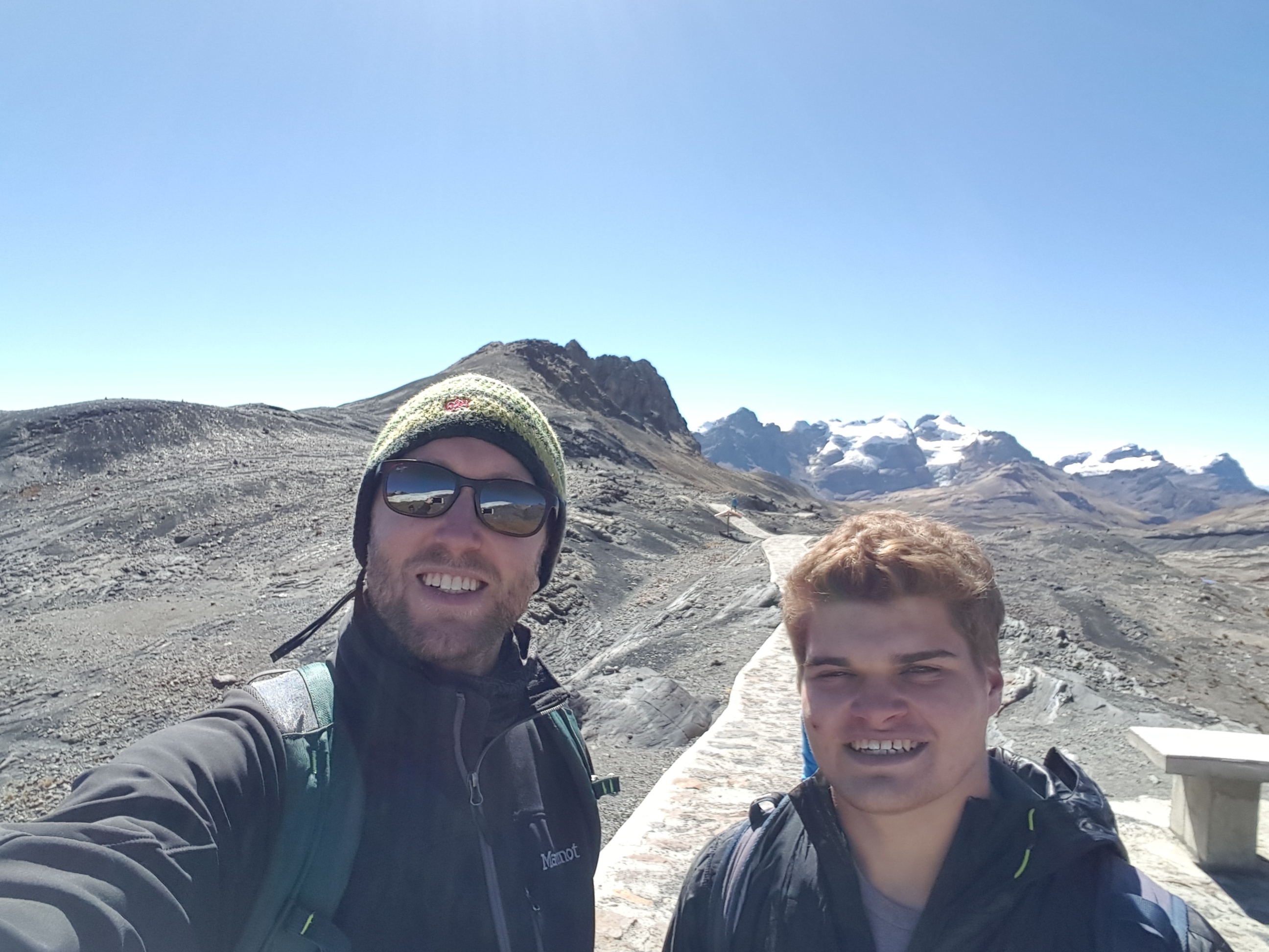
On the way, I started chatting with Julian, a 19 year old student and farmer from Quebec, Canada. He was in Peru to study some of the nativos farming techniques with his uncle, who owned the family farm. We talked a lot about farming, as food and its production is of great interest to me. French was actually his first language and what he spoke almost exclusively, so sometimes he would struggle for words in English and have to describe what he was trying to say, almost like a game of Catchphrase. I also got to teach him several swear words in English, which he was pleased about. We hiked almost the whole way there and back together, bullshitting the whole time except at points where the incline made it hard to breathe.
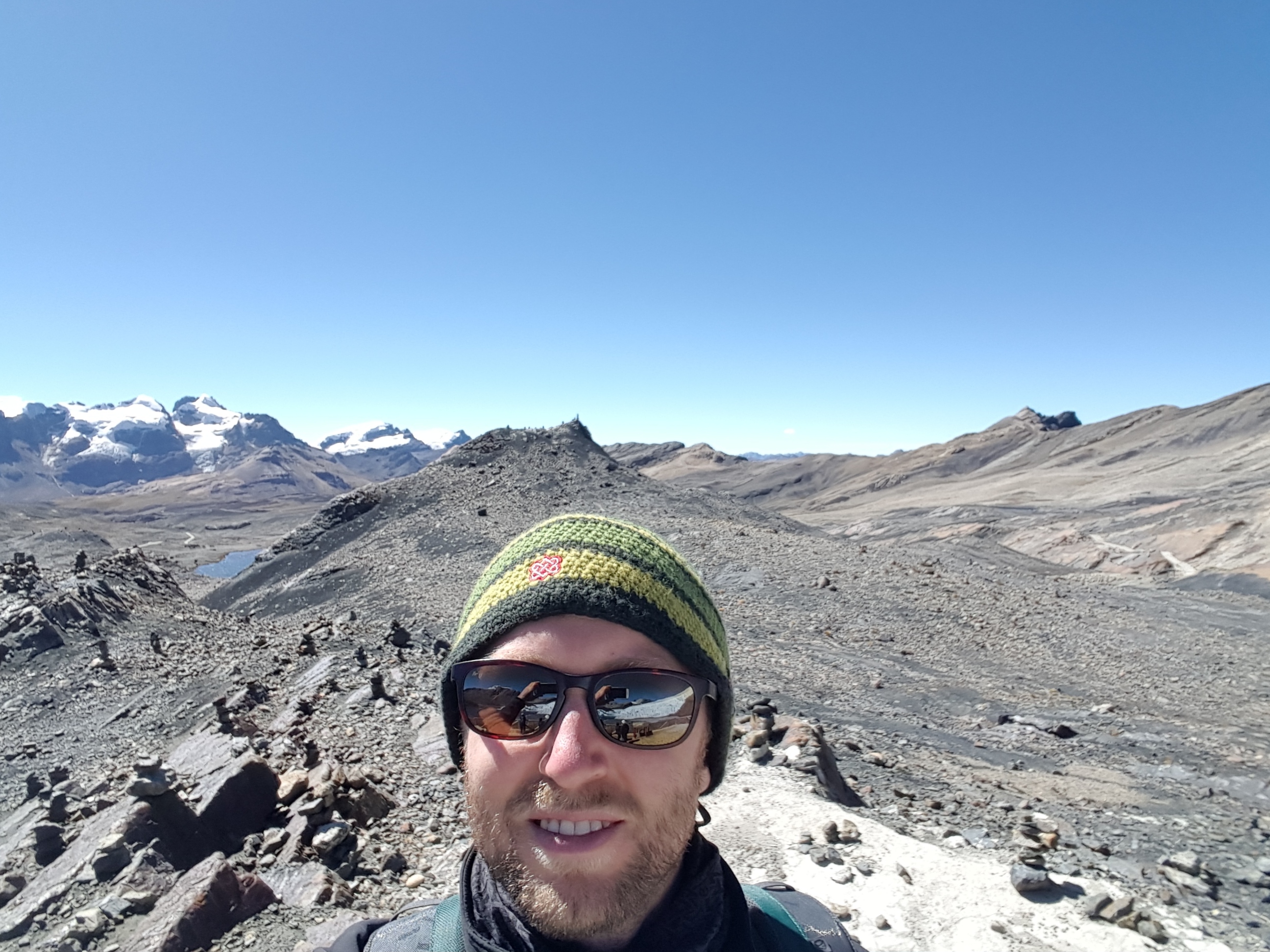
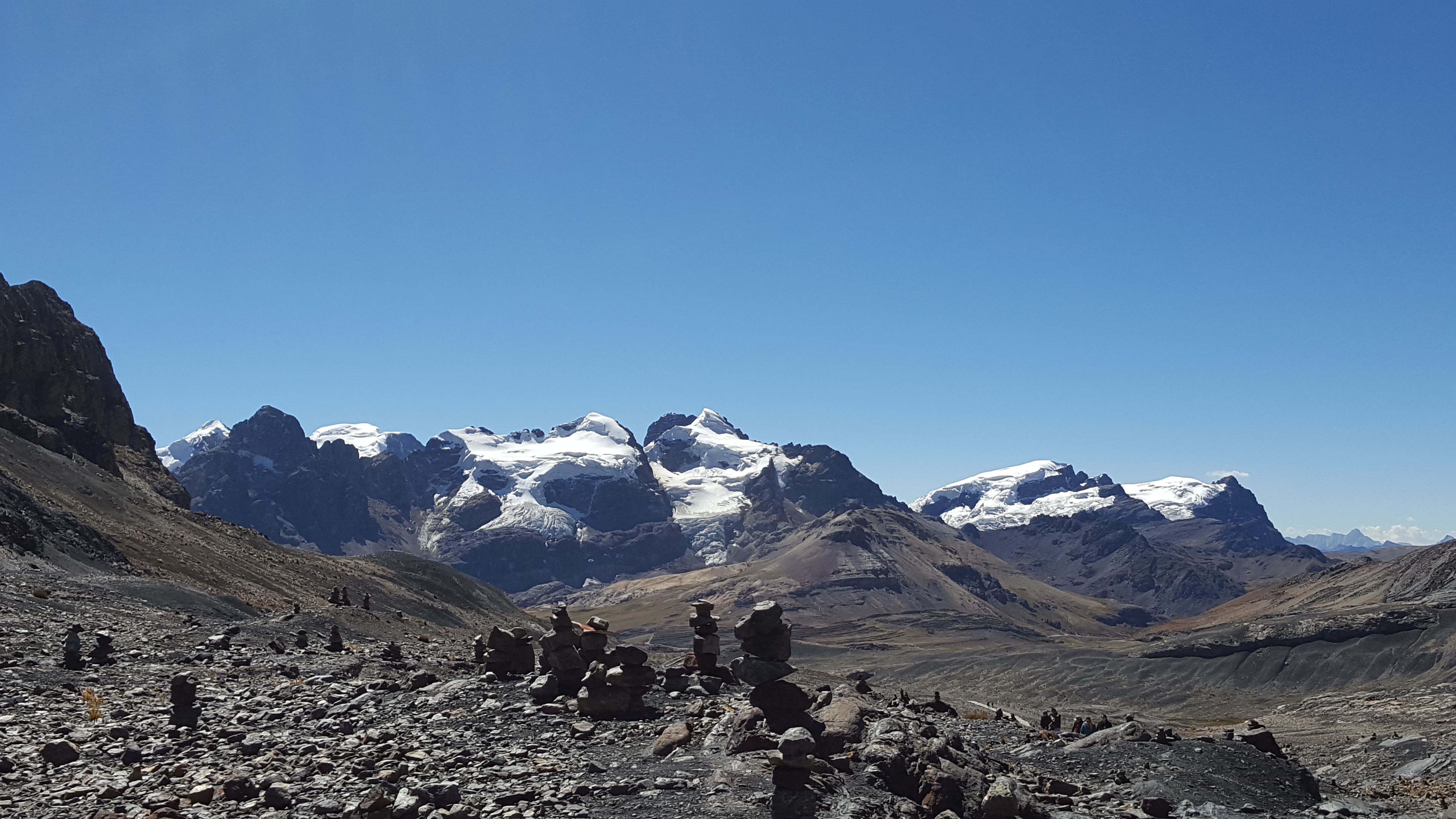
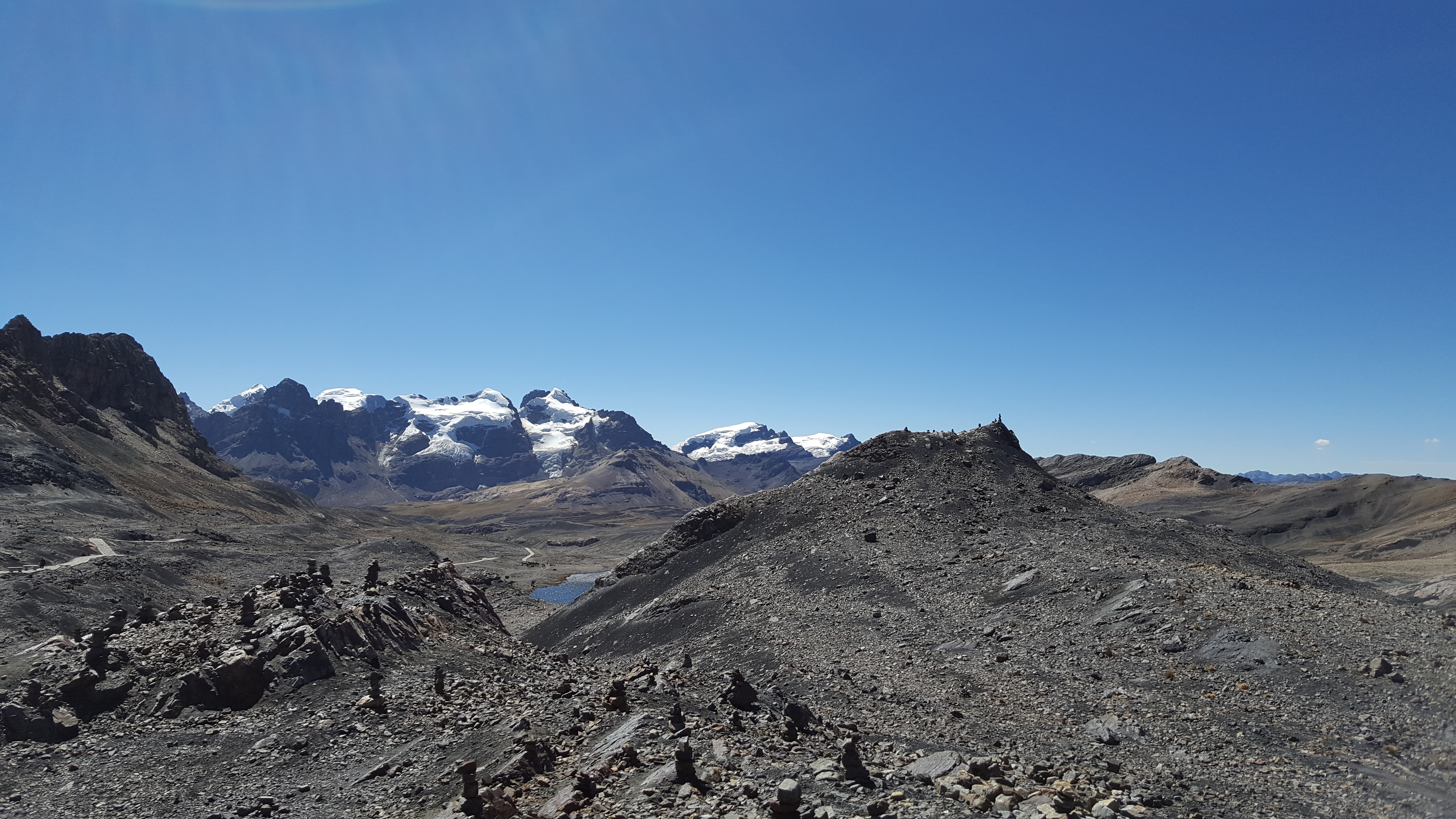
The hike was again a joy of endless beautiful vistas. Whereas the hike to Laguna 69 was through lush valleys and up mountains dotted with trees, shrubs and heather grass, the mountains at Pastoruri were almost all rock with far less vegetation. Yet the entire time you’re viewing unending ranges of snow-capped mountains in the distance, themselves capped by a perfect blue sky. A kind of sublime panorama that makes one feel small and insignificant.

At the conclusion of the hike, I said by to Julian as he was with another tour company, and sat on a curb to eat my lunch. The headache returned, and later that night the ringing in the ears as well, but I didn’t have the horribly fatigued, weak feeling I had from the altitude sickness yesterday. Two more days of hiking and acclimatization in Huaraz and I’d be fit as a horse.
After returning that evening, I went out to eat and tried to treat myself to a nice steak dinner. I earned it, right? Unfortunately, in Peru most places pound out steak to flatten it, then cook it well-done, and it came out like a piece of leather. Note to self, only order steak from a gourmet restaurant where they’ll treat it right. I went to bed early again, and slept well in the cool mountain air.
The next day, I didn’t have any plans. I made breakfast at the hostel, and leisurely enjoyed my morning, drinking several cups of coffee. I spent some time chatting with a guy from Switzerland who was leaving the following day for the 12-day Huayhuash trek. He had recently completed the Santa Cruz trek, which I was still considering doing. He told me all about it, and one of the things he mentioned was to expect to lose 10lbs during the four day trek. That settled that. I had already lost 5-10lbs in the jungle, and frankly don’t have another 10lbs to lose. And my damn pinky toe. Next time.
Around noon I wandered to the area of the city where bus companies have storefronts, and bought a ticket to Trujillo leaving at 11pm, arriving at about 5:30am. I went back to the hostel, and inquired what else there is to do in Huaraz in half a day, that isn’t hiking. I was told there were hot springs nearby, about a 30 minute bus ride away. Hot springs sounded like just the thing my sore body needed.
I had to take a crazy Peruvian bus again, this time without Indra’s help. I found a bus and hopped in, and it started racing north into some pretty desolate, rural areas. Yeah, I had no idea where I was going. When I made eye contact with the doorman on the bus, I asked, “Puede decirme cuando estamos en Chancos, circa de las aguas termales?” Can you tell me when we’re in Chancos, near the hot springs? He winked at me. Ok?
A short while later, the bus pulled over in a remote town and the doorman looked at me, “Chancos.” I paid my S./1.50 as a I got off the bus. Wow, where the hell was I? There were a few fruit stands, some stray dogs running about, and some guys doing steelwork in front of a garage. I walked up a hill, knowing hot springs are usually in the hills. I passed a group of school children who looked at me like an alien. After looking around for a while with no luck, I started asking people. A lady told me it was “lejos y arriba.” Far and above. Good hint. I flagged down a mototaxi, asked him and he said it was far up into the mountains, and agreed to take me for S./5.
After about a 10-15 minute ride, I arrived. I went to the ticket counter and the signs were in Spanish. I had no idea what I wanted, but the guy recommended the “Cueva y banos.” Cave and baths. I agreed, paid S./5 to get in, and went to the cave, a natural salt cave that is basically a sauna. It was fucking amazing. I stayed in the cave for an hour, intermittently leaving the cave to stand under a cold shower for some hot/cold therapy and drink some water. Afterwards, I soaked in the hot springs laden with salts and minerals. I felt like a million bucks when I left. I wish I could do that same program of salt cave and hot spring every day.

That night, I went and re-upped on Don Vito’s Pollo a la Brasa. I headeded back to the hostel, and spent the next few hours writing while watching Peru play Colombia in the Copa America. At 10:40, I left the hostel for the five minute walk to the bus station as Peru was entering a shootout with Colombia. Just outside the bus station, I watched in front of a bar as Peru missed two shots in the shootout to lose. Several people in the bar were down on their knees with hands up to the sky, pleading, as though a loved one had suddenly died. Futbol!

I made my way to the bus station as I heard yelling and bottles breaking a street over. The bus left 30 minutes late, as is typical in Peru, and I was on my way to the north of Peru.
Good write up Matt, We just left Huaraz after doing the Laguna 69 and Santa Cruz hikes! Such good views – took a while to sort through the photos! Have a look – a few of these might take you back to your trip 🙂 http://www.heylookitsjaz.com/2017/10/huaraz-peru/
My friends and I had a similar experience with the hostel too! I gave up on Laguna 69, couldn’t even do a mile. The Pastoruri Glacier was absolutely breathtaking! Great post, chuckled a few times!